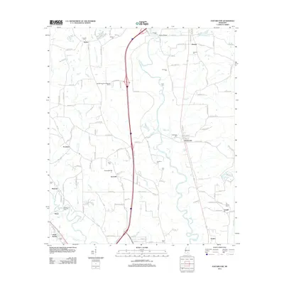
2012 Map of Eastabuchie
USGS Topo · Published 2012About this map
The Leaf River and its various tributaries, including Providence Cr and Bayliss Br, define the landscape of this region north of Hattiesburg. In 2012, this corridor is dominated by the Hattiesburg-Laurel Regional Airport and the north-south transit lines that bisect the rural terrain. Long-established communities such as Eastabuchie and Eatonville are prominent, with the latter situated near the distinct landform of Eatonville Flat. The map reveals a dense concentration of family and community burial grounds, including the Old Leeville Cem, Heidelberg Cem, and Knight Cem, which offer significant value for genealogical research. Water access is noted at the Rapids on the River Boat Ramp along the Bowie River, while the Albeison Bridge serves as a key crossing point in the north, illustrating the intersection of modern infrastructure with the natural drainage patterns of the Pine Belt.
Find a feature on this map
118 named features on this map. Tap any name to fly to it.
Don’t see what you’re looking for? This feature index may not catch every label — zoom into the map to look around manually.
Map Details
Editions of this 2012 Eastabuchie Map
This is the sole edition of this map. No revisions or reprints were ever made.
Other maps of this area

1953 · Hattiesburg
USGS Topo · 1:250,000

1958 · Hattiesburg
USGS Topo · 1:250,000

1963 · Barrontown
USGS Topo · 1:24,000

1964 · Carterville
USGS Topo · 1:24,000

1964 · Seminary
USGS Topo · 1:24,000

1964 · Ellisville
USGS Topo · 1:24,000

1964 · Hattiesburg
USGS Topo · 1:24,000

1965 · Hattiesburg SW
USGS Topo · 1:24,000

1965 · Eastabuchie
USGS Topo · 1:24,000

1965 · Moselle
USGS Topo · 1:24,000