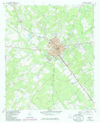
1972 Map of Eastman
USGS Topo · Published 1985About this map
Eastman serves as the central hub of this Dodge County landscape, characterized by the corridor of the Southern railroad and a network of rural churches and family cemeteries. The town's layout shows a transition from the traditional grid near the Southern tracks to expanding residential blocks and civic sites like the Hospital and County High Sch. This 1970s survey, photorevised in the mid-1980s, captures the local infrastructure before modern expansion, including the Eastman-Dodge County Airport and the Radio Tower (WUFF).
Find a feature on this map
40 named features on this map. Tap any name to fly to it.
Don’t see what you’re looking for? This feature index may not catch every label — zoom into the map to look around manually.
Map Details
Editions of this 1972 Eastman Map
2 editions found
Other maps of this area

1956 · Cochran
USGS Topo · 1:62,500

1957 · Macon
USGS Topo · 1:250,000

1958 · Macon
USGS Topo · 1:250,000

1964 · Macon
USGS Topo · 1:250,000

1972 · Eastman
USGS Topo · 1:24,000

1972 · West Of Eastman
USGS Topo · 1:24,000

1972 · Jay Bird Springs
USGS Topo · 1:24,000

1972 · Abbeville North
USGS Topo · 1:24,000
1972 · Milan
USGS Topo · 1:24,000

1972 · Lake Cypress
USGS Topo · 1:24,000