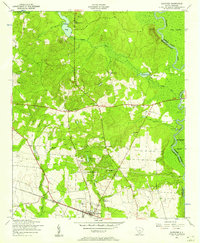
1953 Map of Eastover
USGS Topo · Published 1957About this map
Eastover serves as the primary hub in this mid-century survey of the South Carolina lowcountry, situated where the Atlantic Coast Line railroad cuts through a landscape defined by extensive wetlands and scattered rural congregations. The eastern edge of the quadrangle is dominated by the winding Wateree River and the broad reaches of Gum Swamp and Wateree Swamp, while the interior features a dense network of local landmarks including the Richland County Chain Gang Camp No. 1. This era reveals a deeply rooted community structure, evidenced by the numerous small churches and schools such as Goodwill Church, Antioch School, and Clarkson Mission Church. Smaller water bodies like Wilson Mill Pond and Cates Pond suggest a history of local milling and agriculture shaped by the natural drainage of Colonels Creek and its tributaries.
Find a feature on this map
38 named features on this map. Tap any name to fly to it.
Don’t see what you’re looking for? This feature index may not catch every label — zoom into the map to look around manually.
Map Details
Editions of this 1953 Eastover Map
4 editions found
Other maps of this area

1935 · Killian
USGS Topo · 1:48,000

1937 · Killian
USGS Topo · 1:62,500

1938 · Hagood
USGS Topo · 1:62,500

1941 · Spartanburg
USGS Topo · 1:250,000

1942 · Camden
USGS Topo · 1:125,000

1943 · Eastover
USGS Topo · 1:62,500

1948 · Hopkins
USGS Topo · 1:62,500

1953 · Messers Pond
USGS Topo · 1:24,000

1953 · Poinsett State Park
USGS Topo · 1:24,000

1953 · Eastover
USGS Topo · 1:24,000