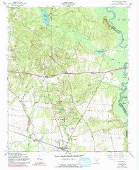
1953 Map of Eastover
USGS Topo · Published 1992About this map
Eastover serves as the primary hub for this section of Richland County, established along the Seaboard Coast Line railroad. The landscape is defined by the transition from the upland elevations near Cooke Mount down to the extensive Wateree Swamp and the winding Wateree River along the eastern boundary. This area is notably dense with historical community centers, particularly churches and schools that served rural congregations and families during the mid-20th century.
Find a feature on this map
37 named features on this map. Tap any name to fly to it.
Don’t see what you’re looking for? This feature index may not catch every label — zoom into the map to look around manually.
Map Details
Editions of this 1953 Eastover Map
4 editions found
Other maps of this area

1935 · Killian
USGS Topo · 1:48,000

1937 · Killian
USGS Topo · 1:62,500

1938 · Hagood
USGS Topo · 1:62,500

1941 · Spartanburg
USGS Topo · 1:250,000

1942 · Camden
USGS Topo · 1:125,000

1943 · Eastover
USGS Topo · 1:62,500

1948 · Hopkins
USGS Topo · 1:62,500

1953 · Messers Pond
USGS Topo · 1:24,000

1953 · Poinsett State Park
USGS Topo · 1:24,000

1953 · Eastover
USGS Topo · 1:24,000