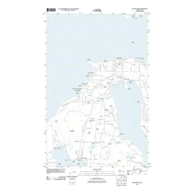
2011 Map of Eastsound
USGS Topo · Published 2011About this map
Orcas Island's northern reaches are detailed here, centered on the community of Eastsound, where the shoreline of Fishing Bay meets Ship Bay. The landscape transitions from the residential and commercial hub near the Eastsound Post Office and Orcas Island Airport to the steep, wooded slopes of Turtleback Mountain and Ship Peak to the west. Evidence of local industry and recreation is peppered throughout the terrain, from the Dolphin Bay Quarry and Sea Island Shale Pit to the Orcas Island Golf Course and Camp Orkila. The coast is defined by numerous points and beaches, including Crescent Beach and Point Doughty, while inland water bodies like Schaefer Lake and Tourtleback Lake are managed by small dams. The map also records the rural character of Crow Valley and the historical presence of Woodlawn Cemetery.
Find a feature on this map
81 named features on this map. Tap any name to fly to it.
Don’t see what you’re looking for? This feature index may not catch every label — zoom into the map to look around manually.
Map Details
Editions of this 2011 Eastsound Map
This is the sole edition of this map. No revisions or reprints were ever made.
Other maps of this area

1943 · Orcas Island
USGS Topo · 1:62,500

1954 · Waldron Island
USGS Topo · 1:24,000

1954 · Friday Harbor
USGS Topo · 1:24,000

1957 · Orcas Island
USGS Topo · 1:62,500

1957 · Victoria
USGS Topo · 1:250,000

1973 · Sucia Island
USGS Topo · 1:24,000

1973 · Shaw Island
USGS Topo · 1:24,000
1973 · Blakely Island
USGS Topo · 1:24,000

1975 · Bellingham
USGS Topo · 1:100,000
1977 · Eastsound
USGS Topo · 1:24,000