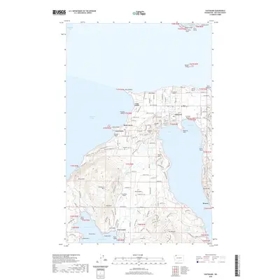
2020 Map of Eastsound
USGS Topo · Published 2020About this map
Orcas Island's northern reaches and the smaller outcrops of Sucia Island are detailed here, centered on the central hub of Eastsound. The island's geography is defined by deep inlets like West Sound and Fishing Bay, which nearly bisect the landmass. This 2020 record captures a landscape where historical homesteading patterns persist alongside modern aviation at Orcas Island Airport and Crow Valley Airport. Genealogy interests are served by the location of Baker Cem and Woodlawn Cem, while the island's interior reveals prominent elevations such as Turtleback Mtn and Mt Woolard. The presence of Camp Orkila and the coastal resort area of Rosario indicate the long-standing recreational character of the archipelago. From the rocky height of Orcas Knob to the sands of Crescent Beach, the map traces a complex shoreline featuring numerous named points like Point Thompson and Madrona Point.
Find a feature on this map
146 named features on this map. Tap any name to fly to it.
Don’t see what you’re looking for? This feature index may not catch every label — zoom into the map to look around manually.
Map Details
Editions of this 2020 Eastsound Map
This is the sole edition of this map. No revisions or reprints were ever made.
Other maps of this area

1943 · Orcas Island
USGS Topo · 1:62,500

1954 · Waldron Island
USGS Topo · 1:24,000

1954 · Friday Harbor
USGS Topo · 1:24,000

1957 · Orcas Island
USGS Topo · 1:62,500

1957 · Victoria
USGS Topo · 1:250,000

1973 · Sucia Island
USGS Topo · 1:24,000

1973 · Shaw Island
USGS Topo · 1:24,000
1973 · Blakely Island
USGS Topo · 1:24,000

1975 · Bellingham
USGS Topo · 1:100,000
1977 · Eastsound
USGS Topo · 1:24,000