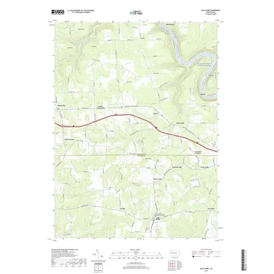
2019 Map of Eau Claire
USGS Topo · Published 2019About this map
The winding Allegheny Wild and Scenic River defines the northeastern corner of this landscape, where the terrain rises toward Wood Hill. This area, straddling the border of Venango and Butler counties, is characterized by a network of small creeks including Scrubgrass Creek and its many forks, which historically supported local industry at sites like Sutton Mill and Sedwicks Mill. The settlement pattern reflects a deeply rooted rural community, with small villages such as Lisbon, Cherry Valley, and Eau Claire connected by long-established roads like the Emlenton Clintonville Rd. Local history and genealogy researchers will find several well-documented burial sites and religious centers, including Unity Cem, Pisgah Cem, and the Farmington Methodist Episcopal Church. The map also captures the geographic importance of junctions such as Riddle Crossroads and Crawford Corners, which served as vital transit points between larger regional hubs like Clintonville.
Find a feature on this map
115 named features on this map. Tap any name to fly to it.
Don’t see what you’re looking for? This feature index may not catch every label — zoom into the map to look around manually.
Map Details
Editions of this 2019 Eau Claire Map
This is the sole edition of this map. No revisions or reprints were ever made.
Other maps of this area

1907 · Foxburg
USGS Topo · 1:62,500

1908 · Foxburg
USGS Topo · 1:62,500

1909 · Franklin
USGS Topo · 1:62,500

1910 · Hilliards
USGS Topo · 1:62,500

1911 · Franklin
USGS Topo · 1:62,500

1912 · Hilliards
USGS Topo · 1:62,500

1922 · Oil City
USGS Topo · 1:48,000

1924 · Oil City
USGS Topo · 1:62,500

1943 · Oil City
USGS Topo · 1:62,500

1944 · Hilliards
USGS Topo · 1:62,500