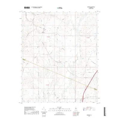
2018 Map of Ebenezer
USGS Topo · Published 2018About this map
Ebenezer serves as the central hub of this agricultural landscape in Holmes County, where a network of rural roads such as Ebenezer Coxburg Rd and Ebenezer Pickens Rd connect disparate homesteads. The terrain is deeply defined by its drainage patterns, with Big Cypress Cr and its tributaries carving through the hills. This 2018 survey reveals a high concentration of small family and community burial grounds, including Rule Cem, Truly Cem, and Hopewell Cem, which suggest the deep genealogical roots of the local population. Along the southern boundary, the transition into Yazoo County is marked near Anderson Cem, while the eastern portion of the map is characterized by the winding path of Bisland Bayou. The placement of these cemeteries and the winding nature of routes like Swayze Home Place Rd reflect a settlement pattern dictated by the undulating topography and the historical location of local estates.
Find a feature on this map
57 named features on this map. Tap any name to fly to it.
Don’t see what you’re looking for? This feature index may not catch every label — zoom into the map to look around manually.
Map Details
Editions of this 2018 Ebenezer Map
This is the sole edition of this map. No revisions or reprints were ever made.
Other maps of this area
1940 · Lexington
USGS Topo · 1:62,500
1953 · Meridian
USGS Topo · 1:250,000

1953 · Greenwood
USGS Topo · 1:250,000
1953 · West Point
USGS Topo · 1:250,000

1955 · Jackson
USGS Topo · 1:250,000

1956 · Greenwood
USGS Topo · 1:250,000
1957 · Meridian
USGS Topo · 1:250,000
1957 · Lexington
USGS Topo · 1:62,500
1958 · West Point
USGS Topo · 1:250,000
1958 · Lexington
USGS Topo · 1:62,500