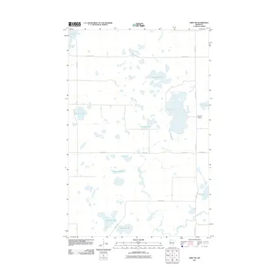
2011 Map of Ebro NW
USGS Topo · Published 2011About this map
Sugar Bush Lake and a dense network of glacial water bodies dominate this Polk County landscape, reflecting the intricate hydrology of northwestern Minnesota. The Wild Rice River meanders across the southern portion of the sheet, fed by a series of drainages including Sugar Bush Creek and Island Lake Creek. This area is characterized by family-named landmarks such as Matt Ayers Lake, Simonson Lake, and Snetsinger Lake, which point to the history of local settlement and land ownership. Cultural sites are concentrated along the roadway network, most notably at the Saint Agnes Catholic Cemetery located along County Hwy-4 on the eastern edge. The map captures a largely rural, water-defined environment where township roads like Pine Bend Rd connect isolated lakes like Annawaush Lake and Washington Lake through the undulating wetland terrain.
Find a feature on this map
32 named features on this map. Tap any name to fly to it.
Don’t see what you’re looking for? This feature index may not catch every label — zoom into the map to look around manually.
Map Details
Editions of this 2011 Ebro NW Map
This is the sole edition of this map. No revisions or reprints were ever made.
Other maps of this area

1919 · Fosston
USGS Topo · 1:62,500

1954 · Bemidji
USGS Topo · 1:250,000

1957 · Bemidji
USGS Topo · 1:250,000

1958 · Bemidji
USGS Topo · 1:250,000

1969 · North Twin Lake
USGS Topo · 1:24,000

1969 · Ebro
USGS Topo · 1:24,000

1969 · Roy Lake
USGS Topo · 1:24,000

1969 · Fosston SE
USGS Topo · 1:24,000

1969 · Fosston East
USGS Topo · 1:24,000

1969 · Fosston West
USGS Topo · 1:24,000