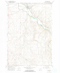
1968 Map of Echo
USGS Topo · Published 1970About this map
The town of Echo serves as the central hub of this 1968 landscape, situated where the Umatilla River and the Union Pacific railroad corridor meet. This area reflects a highly managed agricultural environment, defined by an intricate network of irrigation infrastructure including the Echo Meadows Ditch, Feed Canal, and Furnish Ditch. These systems divert water from the river to the surrounding Echo Meadows, sustaining the local economy.
Find a feature on this map
25 named features on this map. Tap any name to fly to it.
Don’t see what you’re looking for? This feature index may not catch every label — zoom into the map to look around manually.
Map Details
Editions of this 1968 Echo Map
This is the sole edition of this map. No revisions or reprints were ever made.
Other maps of this area

1908 · Umatilla
USGS Topo · 1:125,000

1953 · Pendleton
USGS Topo · 1:250,000

1956 · Pendleton
USGS Topo · 1:250,000

1962 · Stanfield
USGS Topo · 1:24,000

1962 · Hermiston
USGS Topo · 1:24,000

1962 · Stanfield SE
USGS Topo · 1:24,000
1968 · Echo SE
USGS Topo · 1:24,000
1968 · Nolin
USGS Topo · 1:24,000

1968 · Vey Ranch
USGS Topo · 1:24,000
1968 · Service Buttes
USGS Topo · 1:24,000