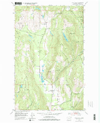
1952 Map of Echo Valley
USGS Topo · Published 1976About this map
Echo Mountain and its surrounding heights dominate this corner of Stevens County, reflecting a landscape defined by both timbered ridges and a persistent mining heritage. In the early 1950s, the small community of Echo served as a local anchor along Echo Valley Road, near where the Bruce Creek School and Bruce Creek Grange formed the social core of the valley. The map documents an active extractive history, with numerous operations such as the Bonanza Mine and Leadville Mine tucked into the slopes of Swede Hill and Bonanza Hill. Water is a central feature here, with the Lake City Lakes and Echo Lake threading through the valley floor, while names like Peterson Swamp and Harbison Gulch speak to the family-led settlement of the terrain. The presence of the Eureka Surprise and Hi Cliff Mine underscores the era's focus on the mineral wealth found within these eastern Washington hills.
Find a feature on this map
38 named features on this map. Tap any name to fly to it.
Don’t see what you’re looking for? This feature index may not catch every label — zoom into the map to look around manually.
Map Details
Editions of this 1952 Echo Valley Map
3 editions found
Other maps of this area

1929 · Colville
USGS Topo · 1:125,000

1933 · Colville
USGS Topo · 1:125,000

1936 · Marcus
USGS Topo · 1:96,000

1942 · Marcus
USGS Topo · 1:125,000

1948 · Kettle Falls
USGS Topo · 1:62,500

1948 · Orient
USGS Topo · 1:62,500

1951 · Orient
USGS Topo · 1:62,500

1951 · Kettle Falls
USGS Topo · 1:62,500

1952 · Gillette Mtn
USGS Topo · 1:24,000

1952 · Echo Valley
USGS Topo · 1:24,000