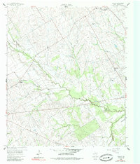
1960 Map of Echols
USGS Topo · Published 1985About this map
The Navasota River and its meandering tributaries, including Mustang Creek and Pin Oak Creek, define the landscape of this Limestone County region. By the early 1960s, the rural community structure was anchored by small crossroads and family-named landmarks. The settlement of Echols is centered around the Echols Sch, while the northern portion of the map is dominated by the town of Coolidge, which sits near the Coolidge Cem and several older burial grounds like Armour Cem and New Armour Cem. Evidence of earlier infrastructure is visible in the Old Railroad Grade that cuts across the terrain north of the river. Small country congregations are frequent, with Mustang Chapel, Sandy Grove Ch, and Frosa Chapel serving as community hubs for local residents and genealogy researchers tracing roots in central Texas.
Find a feature on this map
20 named features on this map. Tap any name to fly to it.
Don’t see what you’re looking for? This feature index may not catch every label — zoom into the map to look around manually.
Map Details
Editions of this 1960 Echols Map
2 editions found
Other maps of this area

1920 · Mart
USGS Topo · 1:62,500

1954 · Waco
USGS Topo · 1:250,000

1955 · Waco
USGS Topo · 1:250,000

1956 · Hubbard
USGS Topo · 1:24,000

1956 · Mart
USGS Topo · 1:24,000

1957 · Prairie Hill
USGS Topo · 1:24,000

1957 · Groesbeck
USGS Topo · 1:62,500

1960 · Echols
USGS Topo · 1:24,000

1960 · Groesbeck
USGS Topo · 1:24,000

1960 · Tehuacana
USGS Topo · 1:24,000