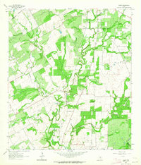
1961 Map of Ecleto
USGS Topo · Published 1964About this map
The Person Oil Field defines much of the industrial landscape in this region of South Texas during the early 1960s. Located along the boundary of Wilson and Karnes Counties, the area is characterized by a network of rural roads connecting scattered homesteads and small agricultural centers. The settlement of Harmony and the village of Ecleto serve as local hubs, while smaller landmarks like the Treybig Cem and Gillett Sch provide vital links for those tracing family history and local genealogy. Hydrological features including Ecleto Creek, Rhymes Creek, and Tom White Hollow carve through the terrain, illustrating the drainage patterns that shaped early settlement. Commercial activity is further evidenced by several Quarries and a Substation, reflecting a period of mid-century development where oil extraction and rural life existed side by side.
Find a feature on this map
18 named features on this map. Tap any name to fly to it.
Don’t see what you’re looking for? This feature index may not catch every label — zoom into the map to look around manually.
Map Details
Editions of this 1961 Ecleto Map
2 editions found
Other maps of this area

1920 · Smiley
USGS Topo · 1:125,000

1953 · Beeville
USGS Topo · 1:250,000

1953 · Seguin
USGS Topo · 1:250,000

1956 · Beeville
USGS Topo · 1:250,000

1956 · Karnes City
USGS Topo · 1:62,500

1958 · Seguin
USGS Topo · 1:250,000

1960 · Beeville
USGS Topo · 1:250,000
1960 · Karnes City
USGS Topo · 1:24,000

1960 · Kosciusko
USGS Topo · 1:24,000

1960 · Helena
USGS Topo · 1:24,000