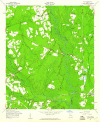
1958 Map of Eden
USGS Topo · Published 1961About this map
Ogeechee River bottomlands and the branching corridors of Black Creek dominate this 1950s landscape where Bulloch, Bryan, and Effingham counties meet. The settlement pattern is defined by the convergence of major rail lines and rural roads, with Blitchton and Meldrim serving as local hubs. The area is dense with community landmarks from the mid-century, including numerous small country churches like Eldora Ch, Olive Branch Ch, and Sand Hill Ch.
Find a feature on this map
35 named features on this map. Tap any name to fly to it.
Don’t see what you’re looking for? This feature index may not catch every label — zoom into the map to look around manually.
Map Details
Editions of this 1958 Eden Map
2 editions found
Other maps of this area

1919 · Egypt
USGS Topo · 1:62,500

1920 · Pembroke
USGS Topo · 1:62,500

1920 · Meldrim
USGS Topo · 1:62,500

1921 · Brooklet
USGS Topo · 1:62,500

1939 · Egypt
USGS Topo · 1:62,500

1942 · Meldrim
USGS Topo · 1:62,500

1943 · Brooklet
USGS Topo · 1:62,500

1943 · Egypt
USGS Topo · 1:62,500

1947 · Savannah
USGS Topo · 1:250,000

1948 · Savannah
USGS Topo · 1:250,000