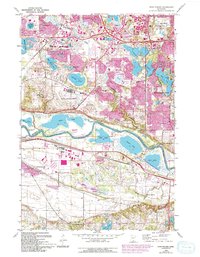
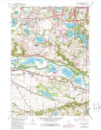
1967 Map of Eden Prairie
USGS Topo · Published 1994About this map
The Minnesota River carves a deep valley through the heart of this landscape, separating Eden Prairie and Bloomington in Hennepin County from Shakopee in Scott County. During the late 1960s, this area was undergoing a significant transition from rural lake country to suburban expansion, visible in the purple revisions that highlight new developments around Rowland and Edina. Industrial and recreational interests are well-represented by the sprawling Flying Cloud Airport and the numerous lakeside parks. Historically, the river served as the primary corridor of commerce and travel, evidenced by the site of Bloomington Ferry and the Chicago and North Western railroad line. Pockets of preserved land like the Minnesota Valley National Wildlife Refuge contrast with localized industry, such as the Quarry and Sandpit sites, while older community anchors like Eden Prairie Cem and Boiling Springs provide genealogical touchstones.
Find a feature on this map
51 named features on this map. Tap any name to fly to it.
Don’t see what you’re looking for? This feature index may not catch every label — zoom into the map to look around manually.
Map Details
Editions of this 1967 Eden Prairie Map
5 editions found
Other maps of this area

1896 · Minneapolis
USGS Topo · 1:62,500

1901 · Minneapolis
USGS Topo · 1:62,500

1905 · Minnetonka
USGS Topo · 1:62,500

1907 · Minnetonka
USGS Topo · 1:62,500

1952 · Minneapolis South
USGS Topo · 1:24,000

1953 · Saint Paul
USGS Topo · 1:250,000

1954 · Hopkins
USGS Topo · 1:24,000

1954 · Bloomington
USGS Topo · 1:24,000

1954 · Eden Prairie
USGS Topo · 1:24,000

1954 · Minneapolis
USGS Topo · 1:62,500