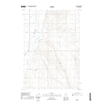
2020 Map of Edgar
USGS Topo · Published 2020About this map
Edgar sits along the Clarks Fork Yellowstone River, serving as a central hub in a landscape defined by its complex irrigation network. The presence of the Edgar Canal, Orchard Canal, Prosperity-Granite Ditch, and O'Connor Ditch illustrates the vital role of water management in this Carbon County region. To the north, Rockvale Cem stands as a point of interest for genealogists, while the Po in town marks the civic center. East of the river, the terrain rises toward Two Bear Ridge, deeply incised by drainages such as Fivemile Cr and its northern fork. This 2020 survey documents the modern state of these rural Montana waterways and the road network, including Homesteader Rd and the Fromberg-Edgar Back Rd, which connect the river valley to the higher benches and coulees.
Find a feature on this map
28 named features on this map. Tap any name to fly to it.
Don’t see what you’re looking for? This feature index may not catch every label — zoom into the map to look around manually.
Map Details
Editions of this 2020 Edgar Map
This is the sole edition of this map. No revisions or reprints were ever made.
Other maps of this area

1954 · Billings
USGS Topo · 1:250,000

1956 · Bridger
USGS Topo · 1:24,000

1956 · Silesia
USGS Topo · 1:24,000

1956 · Fromberg
USGS Topo · 1:24,000

1956 · Edgar
USGS Topo · 1:24,000
1956 · Montaqua
USGS Topo · 1:24,000

1957 · Billings
USGS Topo · 1:250,000

1958 · Billings
USGS Topo · 1:250,000

1967 · Section House Draw
USGS Topo · 1:24,000

1967 · Bluewater
USGS Topo · 1:24,000