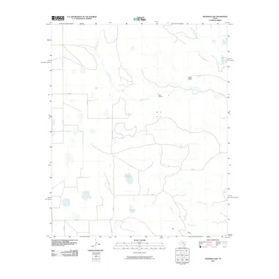
2010 Map of Edgemon Lake
USGS Topo · Published 2010About this map
Edgemon Lake and Emerson Lake anchor this portion of Briscoe County, revealing a landscape defined by the drainage networks of the Texas Panhandle. The topography is shaped by the winding course of Los Lingos Creek, which features the named Lingos Falls. These watercourses create a distinct series of breaks and depressions, including the notable Dark Canyon and Dobbs Hollow, which interrupt the surrounding high plains. The map illustrates a transitional environment where seasonal creeks like Turkey Creek and Hackberry Creek carve through the terrain. The road network is sparse, consisting primarily of county routes like Co RD 17 and Co RD 8, alongside FM 689, reflecting the agricultural and ranching character of this rural region. Small water sources such as Red Rock Spring point to the critical role of localized hydrology in an otherwise semi-arid environment.
Find a feature on this map
18 named features on this map. Tap any name to fly to it.
Don’t see what you’re looking for? This feature index may not catch every label — zoom into the map to look around manually.
Map Details
Editions of this 2010 Edgemon Lake Map
This is the sole edition of this map. No revisions or reprints were ever made.
Other maps of this area

1954 · Plainview
USGS Topo · 1:250,000

1958 · Plainview
USGS Topo · 1:250,000

1965 · Whiteley
USGS Topo · 1:24,000

1965 · Silverton
USGS Topo · 1:24,000

1966 · South Plains
USGS Topo · 1:24,000

1967 · Quitaque
USGS Topo · 1:24,000

1967 · Quitaque Peaks
USGS Topo · 1:24,000

1967 · Edgemon Lake
USGS Topo · 1:24,000

1967 · Hay Lake
USGS Topo · 1:24,000
1967 · Wilson Creek
USGS Topo · 1:24,000