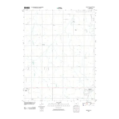
2009 Map of Edgerton
USGS Topo · Published 2009About this map
The community of Edgerton anchors the southeast corner of this landscape, where the town layout meets the headwaters of Martin Creek. This agricultural region is defined by a dense grid of rural roads and numerous family and community burial grounds, including the Old Black Jack Cemetery and Black Jack Cemetery near the historic Black Jack settlement. Further north, the small crossroads of Clearfield sits surrounded by working farms and the winding paths of Captain Creek and its tributaries, such as Wimore Creek. The surveyor's notes indicate a terrain well-drained by several watercourses like Little Wakarusa Creek and Spoon Creek, which carve through the plains. Local landmarks like Konitz Airport and scattered sites such as Adams Cemetery and Pleasant Valley Cemetery provide specific points of interest for genealogists tracing early homesteads in the area.
Find a feature on this map
50 named features on this map. Tap any name to fly to it.
Don’t see what you’re looking for? This feature index may not catch every label — zoom into the map to look around manually.
Map Details
Editions of this 2009 Edgerton Map
This is the sole edition of this map. No revisions or reprints were ever made.
Other maps of this area

1885 · Lawrence
USGS Topo · 1:125,000

1887 · Olathe
USGS Topo · 1:125,000

1889 · Lawrence
USGS Topo · 1:125,000

1893 · Olathe
USGS Topo · 1:125,000

1947 · Lawrence
USGS Topo · 1:250,000

1950 · Lawrence
USGS Topo · 1:250,000
1950 · Lawrence East
USGS Topo · 1:24,000

1951 · De Soto
USGS Topo · 1:24,000
1951 · Eudora
USGS Topo · 1:24,000

1956 · Wellsville
USGS Topo · 1:24,000