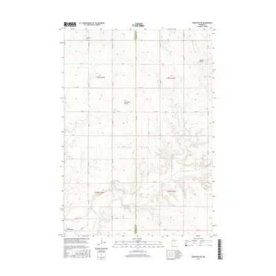
2016 Map of Edgerton NE
USGS Topo · Published 2016About this map
Coteau des Prairies defines the physical character of this southwest Minnesota landscape, where the rising elevation of Buffalo Ridge separates the drainage basins of the region. The agricultural grid is firmly established across the Pipestone and Murray County line, anchored by the settlement of Edgerton in the southwest corner. Waterways such as Chanarambie Cr and the N Br Chanarambie Cr cut through the undulating terrain, following natural depressions between the higher ridges. Genealogists and local historians will find the Woodstock Cem in the northern portion of the quadrangle, serving as a landmark for the rural community. The map illustrates the 21st-century road network, including Co Hwy 5 and Co Line Ave, which follow the township and range lines of the Public Land Survey System.
Find a feature on this map
38 named features on this map. Tap any name to fly to it.
Don’t see what you’re looking for? This feature index may not catch every label — zoom into the map to look around manually.
Map Details
Editions of this 2016 Edgerton NE Map
This is the sole edition of this map. No revisions or reprints were ever made.
Other maps of this area
1953 · Watertown
USGS Topo · 1:250,000
1953 · New Ulm
USGS Topo · 1:250,000
1954 · Fairmont
USGS Topo · 1:250,000
1955 · Sioux Falls
USGS Topo · 1:250,000
1957 · New Ulm
USGS Topo · 1:250,000
1958 · New Ulm
USGS Topo · 1:250,000
1958 · Sioux Falls
USGS Topo · 1:250,000
1958 · Fairmont
USGS Topo · 1:250,000
1958 · Watertown
USGS Topo · 1:250,000
1967 · New Ulm
USGS Topo · 1:250,000