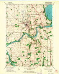
1961 Map of Edgerton
USGS Topo · Published 1964About this map
The Chicago Milwaukee St Paul and Pacific railroad cuts a diagonal path through Edgerton, a town defined by its tobacco heritage and river proximity during the early 1960s. The Rock River snakes through the southern half of the landscape, feeding into the southwestern corner of Lake Koshkonong near Olsons Bay. The importance of aviation to the local economy is evident through both the Tobacco City Airport and the Rock River Landing Strip.
Find a feature on this map
32 named features on this map. Tap any name to fly to it.
Don’t see what you’re looking for? This feature index may not catch every label — zoom into the map to look around manually.
Map Details
Editions of this 1961 Edgerton Map
2 editions found
Other maps of this area

1890 · Stoughton
USGS Topo · 1:62,500

1891 · Koshkonong
USGS Topo · 1:62,500

1891 · Janesville
USGS Topo · 1:62,500

1893 · Janesville
USGS Topo · 1:62,500

1893 · Shopiere
USGS Topo · 1:62,500

1894 · Koshkonong
USGS Topo · 1:62,500

1906 · Koshkonong
USGS Topo · 1:62,500

1954 · Rockford
USGS Topo · 1:250,000

1955 · Rockford
USGS Topo · 1:250,000

1958 · Rockford
USGS Topo · 1:250,000