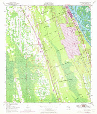
1950 Map of Edgewater
USGS Topo · Published 1972About this map
Indian River North defines the eastern edge of this coastal landscape, where the town of Edgewater and its southern neighbor Hucomer sit atop a series of Spanish land grants. These vast colonial-era parcels, such as the Samuel Betts Grant and John Bolton Grant, create a unique cadastral pattern that underlies the mid-century development of the Florida coast. The Florida East Coast railroad corridor bisects the terrain, establishing local landmarks like Edgewater Junction and providing a transportation spine through the lowlands south to Creighton. The 1970 photorevision highlights the growth of residential blocks and recreational features, including a Drive-in Theater near Sand Point, while interior sections like Massey Ranch and the wetlands around Little Cow Creek remain more sparsely settled, preserving the original land grant boundaries and early telephone line routes.
Find a feature on this map
31 named features on this map. Tap any name to fly to it.
Don’t see what you’re looking for? This feature index may not catch every label — zoom into the map to look around manually.
Map Details
Editions of this 1950 Edgewater Map
5 editions found
Other maps of this area

1937 · Port Orange
USGS Topo · 1:48,000

1943 · Port Orange
USGS Topo · 1:62,500

1944 · Port Orange
USGS Topo · 1:62,500

1949 · Oak Hill
USGS Topo · 1:24,000

1949 · Osceola
USGS Topo · 1:24,000

1950 · Maytown
USGS Topo · 1:24,000

1950 · Ariel
USGS Topo · 1:24,000

1950 · Edgewater
USGS Topo · 1:24,000

1952 · Samsula
USGS Topo · 1:24,000

1954 · Daytona Beach
USGS Topo · 1:250,000