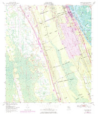
1950 Map of Edgewater
USGS Topo · Published 1984About this map
Large Spanish land grants define the geography of the Volusia County coastline in the mid-20th century, where deep-rooted property lines like the Samuel Betts Grant and John Bolton Grant dictate the layout of modern infrastructure. The Florida East Coast railway parallels the shoreline, serving small coastal communities and industrial points including Edgewater Junction and the small settlement at Creighton. Along the Indian River North, the maritime character of the area is evident through the winding Intracoastal Waterway and geographic markers such as Sand Pt.
Find a feature on this map
34 named features on this map. Tap any name to fly to it.
Don’t see what you’re looking for? This feature index may not catch every label — zoom into the map to look around manually.
Map Details
Editions of this 1950 Edgewater Map
5 editions found
Other maps of this area

1937 · Port Orange
USGS Topo · 1:48,000

1943 · Port Orange
USGS Topo · 1:62,500

1944 · Port Orange
USGS Topo · 1:62,500

1949 · Oak Hill
USGS Topo · 1:24,000

1949 · Osceola
USGS Topo · 1:24,000

1950 · Maytown
USGS Topo · 1:24,000

1950 · Ariel
USGS Topo · 1:24,000

1950 · Edgewater
USGS Topo · 1:24,000

1952 · Samsula
USGS Topo · 1:24,000

1954 · Daytona Beach
USGS Topo · 1:250,000