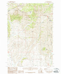
1987 Map of Edie Creek
USGS Topo · Published 1987About this map
The Continental Divide defines the high-altitude boundary of this 1980s topographic study, marking the rugged intersection of the Beaverhead National Forest in Montana and the Targhee National Forest in Idaho. This high-country landscape is shaped by significant peaks and hydrological divides, including the Red Conglomerate Peaks and Knob Mountain. The drainage patterns here are distinct, with Medicine Lodge Creek and Edie Creek carving through the southern terrain, while Beaver Creek flows through the northern reaches near The Thumb. The presence of named features like The Bull Pen and Horse Mountain suggests a landscape historically utilized for livestock and transit through these high passes. This provisional survey captures the complex drainage systems and state-line boundaries at the height of the modern mapping era before digital transitions.
Find a feature on this map
24 named features on this map. Tap any name to fly to it.
Don’t see what you’re looking for? This feature index may not catch every label — zoom into the map to look around manually.
Map Details
Editions of this 1987 Edie Creek Map
This is the sole edition of this map. No revisions or reprints were ever made.
Other maps of this area

1955 · Dubois
USGS Topo · 1:250,000

1957 · Paul Reservoir
USGS Topo · 1:62,500

1957 · Edie Ranch
USGS Topo · 1:62,500

1958 · Dubois
USGS Topo · 1:250,000

1965 · Gallagher Gulch
USGS Topo · 1:24,000

1965 · Lima Peaks
USGS Topo · 1:24,000

1968 · Snowline
USGS Topo · 1:24,000

1983 · Dubois
USGS Topo · 1:100,000
1987 · Indian Creek
USGS Topo · 1:24,000
1987 · Fritz Peak
USGS Topo · 1:24,000