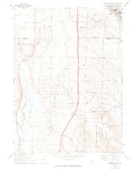
1968 Map of Edinboro South
USGS Topo · Published 1972About this map
Cussewago Creek meanders southward through this rural landscape on the border of Erie and Crawford Counties, defining the drainage of the Cussewago and Hayfield townships. The map documents a period of agricultural stability and conservation, anchored by State Game Lands No 152 and the residential growth around Edinboro Lake in the northeast. Small crossroads communities like Crossingville and Mosiertown serve as focal points for local history, preserving the locations of 19th-century infrastructure such as the Township School.
Find a feature on this map
53 named features on this map. Tap any name to fly to it.
Don’t see what you’re looking for? This feature index may not catch every label — zoom into the map to look around manually.
Map Details
Editions of this 1968 Edinboro South Map
3 editions found
Other maps of this area

1900 · Girard
USGS Topo · 1:62,500

1906 · Linesville
USGS Topo · 1:62,500

1908 · Linesville
USGS Topo · 1:62,500

1923 · Meadville
USGS Topo · 1:62,500

1923 · Cambridge Springs
USGS Topo · 1:62,500

1925 · Meadville
USGS Topo · 1:62,500

1925 · Cambridge Springs
USGS Topo · 1:62,500

1943 · Meadville
USGS Topo · 1:62,500

1943 · Cambridge Springs
USGS Topo · 1:62,500

1950 · Cleveland
USGS Topo · 1:250,000