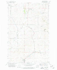
1973 Map of Edwall
USGS Topo · Published 1977About this map
Edwall serves as a focal point in this Lincoln County landscape, situated along the Burlington Northern line and surrounded by the essential infrastructure of Washington's wheat country. The distribution of Grain Elevator facilities and Storage Bins at both Edwall and the Eleanor Grain Elevator siding underscores the area's agricultural reliance on rail transport during the early 1970s.
Find a feature on this map
22 named features on this map. Tap any name to fly to it.
Don’t see what you’re looking for? This feature index may not catch every label — zoom into the map to look around manually.
Map Details
Editions of this 1973 Edwall Map
This is the sole edition of this map. No revisions or reprints were ever made.
Other maps of this area

1945 · Reardan
USGS Topo · 1:62,500

1953 · Reardan
USGS Topo · 1:62,500

1953 · Ritzville
USGS Topo · 1:250,000

1954 · Sprague
USGS Topo · 1:62,500

1955 · Spokane
USGS Topo · 1:250,000

1958 · Spokane
USGS Topo · 1:250,000

1959 · Ritzville
USGS Topo · 1:250,000

1965 · Ritzville
USGS Topo · 1:250,000
1969 · Mondovi
USGS Topo · 1:24,000

1969 · Omans
USGS Topo · 1:24,000