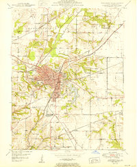
1950 Map of Edwardsville
USGS Topo · Published 1950About this map
Edwardsville serves as a dense municipal and industrial hub at the mid-century, defined by a complex intersection of rail lines including the New York Chicago and St Louis, Illinois Terminal, and Wabash systems. The map illustrates the town's expansion toward the planned industrial village of Le Claire and the waters of Dunlap Lake. Significant civic infrastructure is documented, including the Court House, County Sanitarium, and several schools like the High School and Goshen Sch.
Find a feature on this map
68 named features on this map. Tap any name to fly to it.
Don’t see what you’re looking for? This feature index may not catch every label — zoom into the map to look around manually.
Map Details
Editions of this 1950 Edwardsville Map
2 editions found

Other maps of this area

1888 · St. Louis
USGS Topo · 1:62,500

1907 · Belleville
USGS Topo · 1:62,500

1927 · Alton
USGS Topo · 1:62,500

1927 · Edwardsville
USGS Topo · 1:62,500

1932 · Edwardsville
USGS Topo · 1:62,500

1934 · Alton
USGS Topo · 1:62,500

1935 · Monks Mound
USGS Topo · 1:24,000

1937 · Collinsville
USGS Topo · 1:24,000

1948 · Wood River
USGS Topo · 1:24,000

1949 · Saint Louis
USGS Topo · 1:250,000