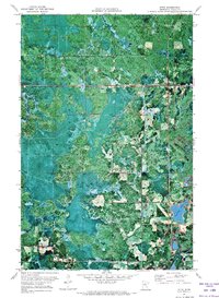
1971 Map of Effie
USGS Topo · Published 1973About this map
Big Fork State Forest dominates this orthophotomap of north-central Minnesota, where the dense timber of the woods meets a complex system of peatlands and river bends. The settlement of Effie serves as the primary outpost in this landscape, situated at the intersection of local routes near the winding course of the Big Fork River. The 1969 aerial photography used to create this sheet reveals a network of Winter Trails that snake through the forest, emphasizing the seasonal nature of transportation and logging in this region. Local life centers around features like Grace Park Ch and the waters of Connors Lake. This specific 1970s record provides a clear look at the early infrastructure of the area, including the Sewage Disposal Ponds, offering researchers a precise spatial view of the community footprint before later developments changed the forest's edge.
Find a feature on this map
7 named features on this map. Tap any name to fly to it.
Don’t see what you’re looking for? This feature index may not catch every label — zoom into the map to look around manually.
Map Details
Editions of this 1971 Effie Map
This is the sole edition of this map. No revisions or reprints were ever made.
Other maps of this area

1918 · Zora
USGS Topo · 1:62,500

1919 · Zora
USGS Topo · 1:62,500

1919 · Marcell
USGS Topo · 1:62,500

1954 · Hibbing
USGS Topo · 1:250,000

1957 · Hibbing
USGS Topo · 1:250,000

1958 · Hibbing
USGS Topo · 1:250,000

1964 · Hibbing
USGS Topo · 1:250,000

1970 · Coon Lake
USGS Topo · 1:24,000
1970 · Spring Lake
USGS Topo · 1:24,000
1970 · Bigfork
USGS Topo · 1:24,000