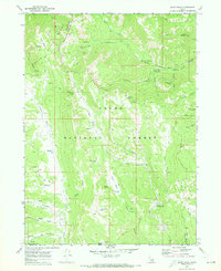
1969 Map of Egan Basin
USGS Topo · Published 1973About this map
The Bear River Range dominates this 1969 survey, where the high-altitude terrain of the Cache National Forest straddles the Idaho and Utah border. This landscape is defined by its complex drainage patterns and tectonic features, most notably the presence of Minnetonka Cave in the northeastern corner and a series of karst depressions simply labeled the Sinks. Water sources are abundant but localized, with high-mountain catchments like Blue Lake, Horse Lake, and Hidden Lake feeding the headwaters of major regional systems.
Find a feature on this map
44 named features on this map. Tap any name to fly to it.
Don’t see what you’re looking for? This feature index may not catch every label — zoom into the map to look around manually.
Map Details
Editions of this 1969 Egan Basin Map
2 editions found
Other maps of this area

1909 · Montpelier
USGS Topo · 1:125,000

1911 · Montpelier
USGS Topo · 1:125,000

1912 · Randolph
USGS Topo · 1:125,000

1914 · Logan
USGS Topo · 1:125,000

1915 · Preston
USGS Topo · 1:96,000

1916 · Logan
USGS Topo · 1:125,000

1918 · Preston
USGS Topo · 1:125,000

1954 · Ogden
USGS Topo · 1:250,000

1955 · Preston
USGS Topo · 1:250,000

1958 · Ogden
USGS Topo · 1:250,000