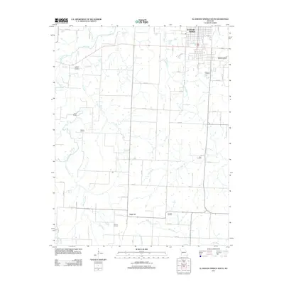
2011 Map of El Dorado Springs South
USGS Topo · Published 2011About this map
El Dorado Springs anchors the northeast corner of this Cedar County landscape, where the town's residential grid meets the open agricultural plains of western Missouri. The map records a rural environment defined by its drainage networks, with Clear Creek and its many tributaries, including Melton Creek and Fly Creek, carving low valleys through the terrain. To the south, the small settlement of Virgil City sits along the county line, accompanied by the Virgil City Cemetery.
Find a feature on this map
56 named features on this map. Tap any name to fly to it.
Don’t see what you’re looking for? This feature index may not catch every label — zoom into the map to look around manually.
Map Details
Editions of this 2011 El Dorado Springs South Map
This is the sole edition of this map. No revisions or reprints were ever made.
Other maps of this area

1886 · Nevada
USGS Topo · 1:125,000

1886 · Stockton
USGS Topo · 1:125,000

1894 · Nevada
USGS Topo · 1:125,000

1937 · Tiffin
USGS Topo · 1:31,680

1939 · Dederick
USGS Topo · 1:24,000

1939 · Eldorado Springs North
USGS Topo · 1:24,000
1939 · Harwood
USGS Topo · 1:24,000

1939 · Filley
USGS Topo · 1:24,000

1939 · Eldorado Springs South
USGS Topo · 1:24,000
1940 · Harwood
USGS Topo · 1:24,000