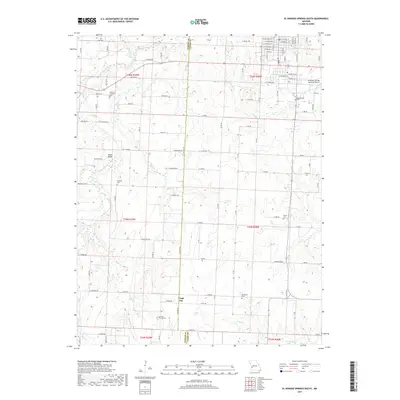
2017 Map of El Dorado Springs South
USGS Topo · Published 2017About this map
Virgil City sits along the line dividing Cedar and Vernon counties, serving as a focal point for this rural landscape south of El Dorado Springs. The area is defined by its numerous family and community burial grounds, including the Clintonville Cem, Whitehall Cem, and Reece Cem, which provide significant points of interest for genealogical research. The terrain is crisscrossed by a network of creeks such as Clear Creek, Alder Cr, and Little Bear Cr, which dictate the placement of local crossings like Kelley Bridge. The presence of the El Dorado Springs Memorial Airport in the northeast corner and the intersection at Sumner Corner highlights the modern transportation infrastructure that overlays this long-settled agricultural region. Many roads, such as E Quantrill Rd and E Rebel Rd, reflect local historical naming conventions within the Osage Nation territory.
Find a feature on this map
114 named features on this map. Tap any name to fly to it.
Don’t see what you’re looking for? This feature index may not catch every label — zoom into the map to look around manually.
Map Details
Editions of this 2017 El Dorado Springs South Map
This is the sole edition of this map. No revisions or reprints were ever made.
Other maps of this area

1886 · Nevada
USGS Topo · 1:125,000

1886 · Stockton
USGS Topo · 1:125,000

1894 · Nevada
USGS Topo · 1:125,000

1937 · Tiffin
USGS Topo · 1:31,680

1939 · Dederick
USGS Topo · 1:24,000

1939 · Eldorado Springs North
USGS Topo · 1:24,000
1939 · Harwood
USGS Topo · 1:24,000

1939 · Filley
USGS Topo · 1:24,000

1939 · Eldorado Springs South
USGS Topo · 1:24,000
1940 · Harwood
USGS Topo · 1:24,000