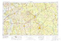
1953 Map of El Dorado
USGS Topo · Published 1978About this map
Oil and gas fields dominate the central landscape of South Arkansas in this mid-century survey, illustrating the industrial footprint that defined the local economy from Smackover to El Dorado. The region’s transportation network is anchored by a dense system of railways, including the Missouri Pacific and St Louis Southwestern, which served the timber and energy sectors. Along the Ouachita River, infrastructure like Lock and Dam No 8 and Lock and Dam No 6 points to the river's role in heavy transit. Beyond the industrial zones, the map details the rural social fabric through landmarks like the University of Arkansas Experiment Station near Hope and several country congregations such as New Hope Church and Harmony Church. Conservation and natural resource management are evident in the sprawling Felsenthal National Wildlife Refuge and the Poison Springs State Forest.
Find a feature on this map
126 named features on this map. Tap any name to fly to it.
Don’t see what you’re looking for? This feature index may not catch every label — zoom into the map to look around manually.
Map Details
Editions of this 1953 El Dorado Map
3 editions found

Other maps of this area

1901 · Gurdon
USGS Topo · 1:125,000

1903 · Camden
USGS Topo · 1:125,000

1906 · Caddo Gap
USGS Topo · 1:125,000

1907 · Atlanta
USGS Topo · 1:62,500

1909 · Texarkana
USGS Topo · 1:62,500

1910 · Atlanta
USGS Topo · 1:62,500

1913 · De Queen
USGS Topo · 1:125,000

1922 · Sarepta
USGS Topo · 1:62,500

1924 · Sarepta
USGS Topo · 1:62,500

1927 · El Dorado
USGS Topo · 1:62,500