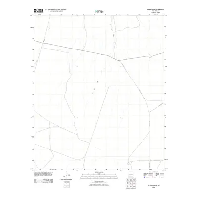
2010 Map of El Paso Draw
USGS Topo · Published 2010About this map
El Paso Draw carves a central path through this arid Otero County landscape, defining the local hydrology alongside its tributary, Wildcat Draw. The terrain is characterized by the widening of El Paso Canyon in the northern portion of the quadrangle, where the ephemeral watercourse begins its descent through the high desert. This 2010 survey illustrates a sparsely developed region where human presence is primarily marked by a network of rural routes, including County Rd F052 and County Rd F050. These corridors provide the only significant access through the desert floor, following the natural contours of the land between the drainages. The map provides a precise record of the topography and land management boundaries in this part of southern New Mexico before more modern infrastructure or land-use changes altered the quiet character of the draw.
Find a feature on this map
6 named features on this map. Tap any name to fly to it.
Don’t see what you’re looking for? This feature index may not catch every label — zoom into the map to look around manually.
Map Details
Editions of this 2010 El Paso Draw Map
This is the sole edition of this map. No revisions or reprints were ever made.
Other maps of this area

1943 · Pendejo Wash
USGS Topo · 1:62,500

1950 · Escondido Canyon
USGS Topo · 1:62,500

1954 · Carlsbad
USGS Topo · 1:250,000

1958 · Carlsbad
USGS Topo · 1:250,000

1965 · Surveyors Canyon
USGS Topo · 1:24,000

1965 · El Paso Canyon
USGS Topo · 1:24,000

1979 · Alamogordo
USGS Topo · 1:100,000
1979 · Otero Mesa South
USGS Topo · 1:24,000

1979 · Crow Flats
USGS Topo · 1:100,000
1980 · El Paso Draw
USGS Topo · 1:24,000