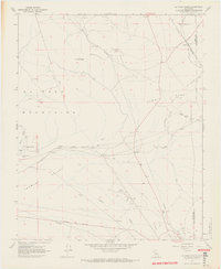
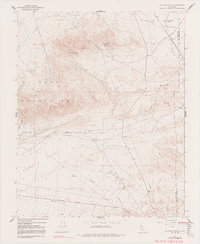
1967 Map of El Paso Peaks
USGS Topo · Published 1968About this map
Yellow Aster Mill (Ruins) stands as a landmark of the region's industrial past, situated near Goler Heights where the high desert meets the El Paso Mountains. This 1960s landscape is defined by its mining and transit history, featuring a network of isolated water sources like Willow Spring Well and Benson Well that were vital for survival in this arid terrain. The Southern Pacific railroad cuts through the southern reaches, connecting the small settlement of Rand with the broader freight network. The map reveals the deep-cut topography of the area, from Fiddler Gulch to the Summit Range, while multiple gravel pits and mines indicate active resource extraction. Evidence of earlier transportation eras remains visible through the Old Railroad Grade, tracing a path that diverges from the mid-century infrastructure.
Find a feature on this map
34 named features on this map. Tap any name to fly to it.
Don’t see what you’re looking for? This feature index may not catch every label — zoom into the map to look around manually.
Map Details
Editions of this 1967 El Paso Peaks Map
5 editions found
Other maps of this area

1903 · Randsburg
USGS Topo · 1:62,500

1911 · Randsburg
USGS Topo · 1:62,500

1912 · Randsburg
USGS Topo · 1:62,500

1915 · Searles Lake
USGS Topo · 1:250,000

1943 · Inyokern
USGS Topo · 1:62,500

1943 · Saltdale
USGS Topo · 1:62,500

1947 · Trona
USGS Topo · 1:250,000

1948 · Trona
USGS Topo · 1:250,000

1953 · Ridgecrest
USGS Topo · 1:62,500

1953 · Trona
USGS Topo · 1:250,000