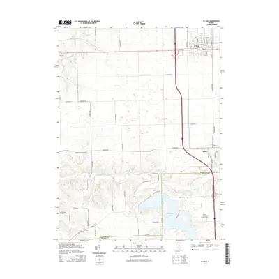
2015 Map of El Paso
USGS Topo · Published 2015About this map
The city of El Paso anchors the northern portion of this Woodford County landscape, showing its characteristic grid and proximity to the Woodford and McLean county line. The terrain transitions from the open agricultural plateaus around Olive Br and Panther Creek into the more complex, wooded drainages of the Mackinaw River valley. This waterway cuts a winding path across the southern half of the sheet, feeding into Evergreen Lake, a significant reservoir that defines the local topography alongside Sixmile Cr. Historically significant sites like Centennial Chapel Cem and Kappa Cem are preserved in the mapping, offering specific points of interest for genealogists tracing local families. To the east, the settlement of Kappa sits near the riverbanks, while the presence of Schertz Aerial Service - Hudson Airport reflects the integration of modern aviation infrastructure within this traditional central Illinois farming region.
Find a feature on this map
71 named features on this map. Tap any name to fly to it.
Don’t see what you’re looking for? This feature index may not catch every label — zoom into the map to look around manually.
Map Details
Editions of this 2015 El Paso Map
This is the sole edition of this map. No revisions or reprints were ever made.
Other maps of this area

1926 · Normal
USGS Topo · 1:62,500

1927 · Danvers
USGS Topo · 1:62,500

1930 · Danvers
USGS Topo · 1:62,500

1930 · Normal
USGS Topo · 1:62,500

1955 · Minonk
USGS Topo · 1:62,500

1958 · Flanagan
USGS Topo · 1:62,500

1958 · Peoria
USGS Topo · 1:250,000

1961 · Peoria
USGS Topo · 1:250,000

1963 · Peoria
USGS Topo · 1:250,000
1970 · Secor
USGS Topo · 1:24,000