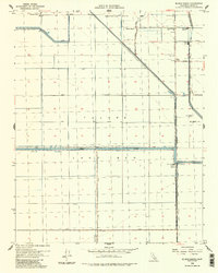
1954 Map of El Rico Ranch
USGS Topo · Published 1985About this map
Tulare Lake Bed defines the topography of this San Joaquin Valley landscape, revealing an intensive agricultural engineering effort in the mid-1950s. The region is crisscrossed by an intricate network of irrigation and drainage infrastructure, including the El Rico Main Canal, Progressive Canal, and the Tule River. Settlement patterns are dominated by large agricultural holdings and worker facilities, such as the Richland Farms Camp, multiple Labor Camps, and named family operations like Peterson Ranch and Johnson Ranch. The presence of the Dallas School and the small siding at Newton indicate the social hubs of this rural farming community. This survey provides a distinct look at the reclaimed lakebed before modern subsidence further altered the terrain, documented through features like Helm Corner and the Gates-Jones Canal.
Find a feature on this map
34 named features on this map. Tap any name to fly to it.
Don’t see what you’re looking for? This feature index may not catch every label — zoom into the map to look around manually.
Map Details
Editions of this 1954 El Rico Ranch Map
3 editions found
Other maps of this area

1914 · Lost Hills
USGS Topo · 1:125,000

1928 · Waukena
USGS Topo · 1:31,680

1928 · Corcoran
USGS Topo · 1:31,680

1929 · Guernsey
USGS Topo · 1:31,680

1929 · Stratford
USGS Topo · 1:31,680

1929 · West Alpaugh
USGS Topo · 1:31,680

1931 · Harvester
USGS Topo · 1:31,680

1932 · El Rico Ranch
USGS Topo · 1:31,680

1932 · Dudley Ridge
USGS Topo · 1:31,680

1933 · Chatom Ranch
USGS Topo · 1:31,680