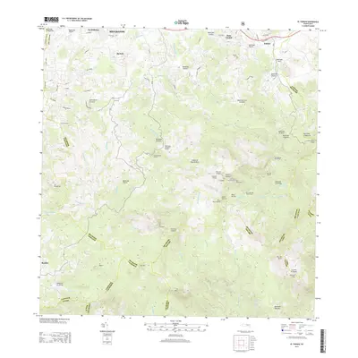
2013 Map of El Yunque
USGS Topo · Published 2013About this map
Pico El Yunque dominates this high-altitude landscape within the Sierra de Luquillo, where the peak is marked by the Torre del Yunque. The complex drainage system of the tropical forest is meticulously documented, showing the headwaters of the Rio Espiritu Santo, Rio Mameyes, and Rio Canóvanas. Recreational landmarks such as the Palo Colorado Picnic Area, Catarata de la Mina, and the Bano de Oro reflect the area's significance as a protected natural resource. While the southern and central portions are defined by steep ridges like El Toro and El Negro, the northern edge reveals rural settlements including Palmer, Hato Candal, and La Dolores. Transportation into the forest is limited to specialized routes like Camino Los Castros, and river crossings such as the Puente Roto Bridge.
Find a feature on this map
98 named features on this map. Tap any name to fly to it.
Don’t see what you’re looking for? This feature index may not catch every label — zoom into the map to look around manually.
Map Details
Editions of this 2013 El Yunque Map
This is the sole edition of this map. No revisions or reprints were ever made.
Other maps of this area

1940 · Carolina
USGS Topo · 1:30,000

1941 · Rio Grande
USGS Topo · 1:30,000

1941 · Carolina
USGS Topo · 1:30,000

1945 · El Yunque
USGS Topo · 1:30,000

1946 · El Yunque
USGS Topo · 1:30,000

1946 · Humacao
USGS Topo · 1:30,000

1946 · Gurabo
USGS Topo · 1:30,000

1946 · Juncos
USGS Topo · 1:30,000

1946 · Naguabo
USGS Topo · 1:30,000

1946 · Fajardo
USGS Topo · 1:30,000
Featured Places
- Sector Rosado, Las Piedras
- Palma Sola, Canóvanas
- Hacienda Jordán, Río Grande
- Colinas Tres T, Río Grande
- Comunidad La Vega, Río Grande