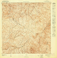
1947 Map of El Yunque SO
USGS Topo · Published 1947About this map
The Sierra de Luquillo range dominates this 1940s topographic study, illustrating the complex watershed of eastern Puerto Rico within the Caribbean National Forest. The map detail follows the steep descent of several major river systems, including the headwaters of the Río Grande de Loíza and the Río Espíritu Santo. Significant high points like El Toro Southwest Peak and El Cacique define the ridgelines that separate the municipal boundaries of Municipio de Rio Grande, Municipio de Naguabo, and Municipio de Juncos. This preliminary survey focuses heavily on the natural hydrology and elevation of the forest reserve before extensive modern development, tracing the paths of the Río Gurabo and Río Cubuy as they flow from the peaks toward the surrounding coastal valleys.
Find a feature on this map
18 named features on this map. Tap any name to fly to it.
Don’t see what you’re looking for? This feature index may not catch every label — zoom into the map to look around manually.
Map Details
Editions of this 1947 El Yunque SO Map
This is the sole edition of this map. No revisions or reprints were ever made.
Other maps of this area

1945 · El Yunque
USGS Topo · 1:30,000

1946 · El Yunque
USGS Topo · 1:30,000

1946 · Humacao
USGS Topo · 1:30,000

1946 · Gurabo
USGS Topo · 1:30,000

1946 · Juncos
USGS Topo · 1:30,000

1947 · El Yunque NE
USGS Topo · 1:10,000
1947 · Gurabo SE
USGS Topo · 1:10,000

1947 · Gurabo NE
USGS Topo · 1:10,000
1947 · Juncos NE
USGS Topo · 1:10,000

1947 · El Yunque SE
USGS Topo · 1:10,000