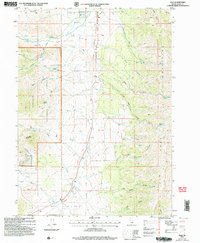
2001 Map of Elba
USGS Topo · Published 2006About this map
Elba Basin serves as the central focal point of this Cassia County landscape, where the small community of Elba is situated near the junction of several mountain drainages. The area is defined by the high elevations of the Sawtooth National Forest to the west and the Jim Sage Mountains to the east. A notable historical corridor, the Historic California National Trail, cuts through the center of the quadrangle, following the natural path provided by the Upper Raft River Valley. This route highlights the region's importance as a passage for westward migration.
Find a feature on this map
58 named features on this map. Tap any name to fly to it.
Don’t see what you’re looking for? This feature index may not catch every label — zoom into the map to look around manually.
Map Details
Editions of this 2001 Elba Map
This is the sole edition of this map. No revisions or reprints were ever made.
Other maps of this area

1954 · Pocatello
USGS Topo · 1:250,000

1958 · Pocatello
USGS Topo · 1:250,000

1968 · Almo
USGS Topo · 1:24,000

1968 · Cache Peak
USGS Topo · 1:24,000

1968 · Jim Sage Canyon
USGS Topo · 1:24,000

1968 · Elba
USGS Topo · 1:24,000

1968 · Kane Canyon
USGS Topo · 1:24,000

1968 · Mount Harrison
USGS Topo · 1:24,000

1968 · Nibbs Creek
USGS Topo · 1:24,000

1968 · Chokecherry Canyon
USGS Topo · 1:24,000