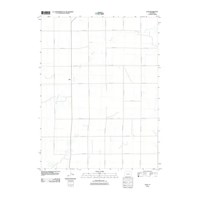
2010 Map of Elba
USGS Topo · Published 2010About this map
Elba stands as the primary focal point of this Eastern Colorado landscape, situated along a north-south transportation corridor in Washington County. The terrain is defined by the winding course of Hell Creek, which meanders from the southwest toward the northeast corner of the quadrangle. This 2010 survey illustrates a highly organized section-line grid system, typical of the High Plains, where agricultural access is maintained through an extensive network of local routes such as County Road BB and County Road GG. The map reveals a sparse, rural settlement pattern where the vast majority of the land is divided by east-west thoroughfares like County Rd-24 and County Rd-28, reflecting the enduring surveyor's grid that governs the region's ranching and farming heritage.
Find a feature on this map
15 named features on this map. Tap any name to fly to it.
Don’t see what you’re looking for? This feature index may not catch every label — zoom into the map to look around manually.
Map Details
Editions of this 2010 Elba Map
This is the sole edition of this map. No revisions or reprints were ever made.
Other maps of this area

1954 · Limon
USGS Topo · 1:250,000

1954 · Sterling
USGS Topo · 1:250,000

1957 · Limon
USGS Topo · 1:250,000

1958 · Limon
USGS Topo · 1:250,000

1958 · Sterling
USGS Topo · 1:250,000

1973 · Antelope Creek East
USGS Topo · 1:24,000

1973 · Antelope Creek SE
USGS Topo · 1:24,000

1973 · Pinneo SE
USGS Topo · 1:24,000

1973 · Akron SE
USGS Topo · 1:24,000
1973 · Akron SW
USGS Topo · 1:24,000