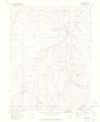
1970 Map of Elbert
USGS Topo · Published 1973About this map
Kiowa Creek and its tributaries carve a network of drainages through this high-plains landscape, which in 1970 served as a rural corridor for ranching and transport. The settlement of Elbert serves as a focal point, situated along an Old Railroad Grade that traces the valley floor, hinting at the area's earlier dependency on rail logistics. Further south, the map documents specialized land uses including the J-CC Camp and the Peaceful Valley Ranch, while the presence of a Landing Strip and a rugged Jeep Trail suggests the modernization of travel in this stretch of the Colorado plateau.
Find a feature on this map
13 named features on this map. Tap any name to fly to it.
Don’t see what you’re looking for? This feature index may not catch every label — zoom into the map to look around manually.
Map Details
Editions of this 1970 Elbert Map
4 editions found
Other maps of this area

1894 · Castle Rock
USGS Topo · 1:125,000

1913 · Castle Rock
USGS Topo · 1:125,000

1939 · Elizabeth
USGS Topo · 1:62,500

1940 · Elbert
USGS Topo · 1:62,500

1944 · Elbert
USGS Topo · 1:62,500

1945 · Elizabeth
USGS Topo · 1:62,500

1953 · Denver
USGS Topo · 1:250,000

1954 · Cherry Valley School
USGS Topo · 1:24,000
1954 · Black Forest
USGS Topo · 1:24,000
1954 · Eastonville
USGS Topo · 1:24,000