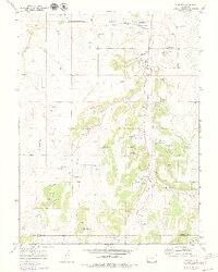
1970 Map of Elbert
USGS Topo · Published 1979About this map
Elbert sits at the center of this 1970s landscape, serving as a hub where the Old Railroad Grade parallels the path of Kiowa Creek. The map reflects a rural community defined by its waterways and small-scale infrastructure, including a local Landing Strip and numerous gravel pits. The presence of the J-CC Camp and the Peaceful Valley Ranch indicates the area's development for recreation and ranching during this era.
Find a feature on this map
14 named features on this map. Tap any name to fly to it.
Don’t see what you’re looking for? This feature index may not catch every label — zoom into the map to look around manually.
Map Details
Editions of this 1970 Elbert Map
4 editions found
Other maps of this area

1894 · Castle Rock
USGS Topo · 1:125,000

1913 · Castle Rock
USGS Topo · 1:125,000

1939 · Elizabeth
USGS Topo · 1:62,500

1940 · Elbert
USGS Topo · 1:62,500

1944 · Elbert
USGS Topo · 1:62,500

1945 · Elizabeth
USGS Topo · 1:62,500

1953 · Denver
USGS Topo · 1:250,000

1954 · Cherry Valley School
USGS Topo · 1:24,000
1954 · Black Forest
USGS Topo · 1:24,000
1954 · Eastonville
USGS Topo · 1:24,000