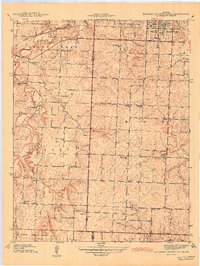
1942 Map of Eldorado Springs South
USGS Topo · Published 1942About this map
Eldorado Springs serves as the focal point of this 1939 survey, situated at the edge of a landscape defined by small rural hubs and an extensive network of country schools. The transition from the town center to the outlying areas of Clintonville and Virgil City reveals a highly decentralized community structure, where education and faith were anchored by dozens of local institutions such as Nine Wonders Sch and Sulphur Springs Ch. The winding courses of Clear Creek and Fly Creek dictate the local geography, connected by landmarks like Kelley Bridge.
Find a feature on this map
34 named features on this map. Tap any name to fly to it.
Don’t see what you’re looking for? This feature index may not catch every label — zoom into the map to look around manually.
Map Details
Editions of this 1942 Eldorado Springs South Map
This is the sole edition of this map. No revisions or reprints were ever made.
Other maps of this area

1886 · Nevada
USGS Topo · 1:125,000

1886 · Stockton
USGS Topo · 1:125,000

1894 · Nevada
USGS Topo · 1:125,000

1937 · Tiffin
USGS Topo · 1:31,680

1939 · Dederick
USGS Topo · 1:24,000

1939 · Eldorado Springs North
USGS Topo · 1:24,000
1939 · Harwood
USGS Topo · 1:24,000

1939 · Filley
USGS Topo · 1:24,000

1939 · Eldorado Springs South
USGS Topo · 1:24,000
1940 · Harwood
USGS Topo · 1:24,000