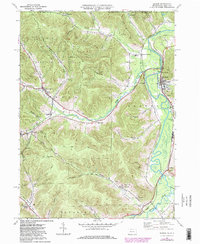
1969 Map of Eldred
USGS Topo · Published 1981About this map
The Bradford Oil Field dominates the high ground of this Pennsylvania-New York borderlands survey, characterized by a dense network of Oil Wells and pipelines cutting through the plateau. This industrial landscape contrasts sharply with the agricultural and river-oriented settlements of Eldred and West Eldred along the winding Allegheny River. The area's mid-century rural infrastructure is well-defined, featuring numerous country burial grounds such as Oak Hill Cem, Lamphier Cem, and Rixford Cem. The river valley serves as a primary transit corridor, where the Conrail line parallels the water, connecting small rail-side communities like Larabee and Coryville at the confluence with Potato Creek. Local education centers like the Otto-Eldred High Sch and several township schools suggest the community hubs that served these northern McKean County villages during the post-war era.
Find a feature on this map
53 named features on this map. Tap any name to fly to it.
Don’t see what you’re looking for? This feature index may not catch every label — zoom into the map to look around manually.
Map Details
Editions of this 1969 Eldred Map
3 editions found
Other maps of this area

1898 · Olean
USGS Topo · 1:62,500

1900 · Salamanca
USGS Topo · 1:62,500

1924 · Bradford
USGS Topo · 1:62,500

1926 · Bradford
USGS Topo · 1:62,500

1933 · Smethport
USGS Topo · 1:62,500

1937 · Smethport
USGS Topo · 1:62,500

1938 · Salamanca
USGS Topo · 1:62,500

1938 · Olean
USGS Topo · 1:62,500

1941 · Bradford
USGS Topo · 1:62,500

1943 · Olean
USGS Topo · 1:62,500