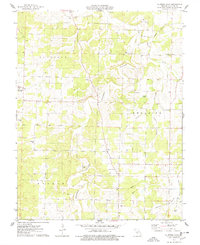
1976 Map of Eldridge East
USGS Topo · Published 1978About this map
Eldridge and Dove anchor this rural Laclede County landscape, surveyed in the mid-1970s. The terrain is characterized by deep hollows and high ridges, notably Goodwin Hollow and Eldridge Hollow, which channel local drainage toward the Dry Auglaize Creek. This topographic detail reveals the sparse, agriculture-based settlement patterns of the era, where small family-named cemeteries such as Hufft Cem, Mizer Cem, and Rogers Cem dot the hillsides, often near local landmarks like Zion Ch or the Goodwin Calvary Ch. Cultural features of the time are evident, including a Drive-in Theater situated along the main roadway and a Radio Tower on a high peak near Holman Hollow. The map provides a clear record of these Ozark foothills before more modern development altered the local road and community structure.
Find a feature on this map
34 named features on this map. Tap any name to fly to it.
Don’t see what you’re looking for? This feature index may not catch every label — zoom into the map to look around manually.
Map Details
Editions of this 1976 Eldridge East Map
2 editions found
Other maps of this area

1933 · Stoutland
USGS Topo · 1:62,500

1934 · Macks Creek
USGS Topo · 1:48,000

1938 · Stoutland
USGS Topo · 1:62,500

1939 · Macks Creek
USGS Topo · 1:62,500

1939 · Long Lane
USGS Topo · 1:62,500

1941 · Lebanon
USGS Topo · 1:62,500

1942 · Long Lane
USGS Topo · 1:62,500

1943 · Lebanon
USGS Topo · 1:62,500

1954 · Springfield
USGS Topo · 1:250,000

1958 · Springfield
USGS Topo · 1:250,000