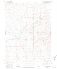
1980 Map of Elevenmile Well
USGS Topo · Published 1981About this map
Evans Creek cuts through this high-desert landscape in northern Nevada, where the intersection of Humboldt and Elko counties meets the northern edge of Lander County. The terrain is defined by its thermal activity and ranching infrastructure, most notably at Hot Springs Ranch and the nearby geothermal features labeled as Spring (Hot) and Springs (Hot). These natural water sources were essential for livestock operations in the Great Basin, supported by scattered improvements like the Lower Clover Ranch and various corrals.
Find a feature on this map
13 named features on this map. Tap any name to fly to it.
Don’t see what you’re looking for? This feature index may not catch every label — zoom into the map to look around manually.
Map Details
Editions of this 1980 Elevenmile Well Map
2 editions found
Other maps of this area

1882 · Paradise
USGS Topo · 1:250,000

1893 · Paradise
USGS Topo · 1:250,000

1932 · Sonoma Range
USGS Topo · 1:250,000

1939 · Sonoma Range
USGS Topo · 1:250,000

1955 · McDermitt
USGS Topo · 1:250,000

1955 · Winnemucca
USGS Topo · 1:250,000

1958 · Winnemucca
USGS Topo · 1:250,000

1959 · McDermitt
USGS Topo · 1:250,000

1962 · Winnemucca
USGS Topo · 1:250,000

1965 · Knight
USGS Topo · 1:24,000