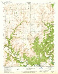
1962 Map of Elgin
USGS Topo · Published 1968About this map
The Old Indian Treaty Boundary slices across this portion of Chautauqua County just north of the Oklahoma border, marking a significant historical line in the landscape. Along the southern edge, the Caney River winds toward the Hulah Res, passing the town of Elgin. This 1960s survey documents a transition in local transportation and industry, showing the path of the Missouri Pacific railroad alongside an Old RR Grade, while scattered Oil Wells and a Quarry suggest the area's economic activities.
Find a feature on this map
21 named features on this map. Tap any name to fly to it.
Don’t see what you’re looking for? This feature index may not catch every label — zoom into the map to look around manually.
Map Details
Editions of this 1962 Elgin Map
3 editions found
Other maps of this area

1885 · Sedan
USGS Topo · 1:125,000

1889 · Sedan
USGS Topo · 1:125,000

1909 · Pawhuska
USGS Topo · 1:125,000

1910 · Pawhuska
USGS Topo · 1:125,000

1955 · Wichita
USGS Topo · 1:250,000

1955 · Enid
USGS Topo · 1:250,000

1958 · Enid
USGS Topo · 1:250,000

1958 · Wichita
USGS Topo · 1:250,000

1962 · Sedan
USGS Topo · 1:24,000
1962 · Cedar Vale East
USGS Topo · 1:24,000