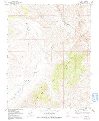
1969 Map of Elgin
USGS Topo · Published 1991About this map
Elgin serves as the primary landmark in this high-desert landscape, situated where the Union Pacific railroad corridor follows the winding course of the Meadow Valley Wash. The map reveals a transition from the broad, alluvial plains of Kane Springs Wash to the dramatic elevation of the Meadow Valley Mountains in the southeastern quadrant. This 1969 field-checked survey documents a region defined by its water-carved topography, including Pennsylvania Canyon and numerous unnamed washes. The presence of several corrals and 4WD tracks suggests a landscape primarily utilized for ranching and remote transit, highlighting the isolation of this corner of Lincoln County before modern developments reached the interior basins.
Find a feature on this map
9 named features on this map. Tap any name to fly to it.
Don’t see what you’re looking for? This feature index may not catch every label — zoom into the map to look around manually.
Map Details
Editions of this 1969 Elgin Map
2 editions found
Other maps of this area

1885 · Pioche
USGS Topo · 1:250,000

1886 · Pioche
USGS Topo · 1:250,000

1954 · Caliente
USGS Topo · 1:250,000

1959 · Caliente
USGS Topo · 1:250,000

1969 · Vigo NW
USGS Topo · 1:24,000

1969 · Elgin
USGS Topo · 1:24,000

1969 · Elgin NE
USGS Topo · 1:24,000

1969 · Slidy Mountain
USGS Topo · 1:24,000
1969 · Vigo NE
USGS Topo · 1:24,000

1969 · Elgin SW
USGS Topo · 1:24,000