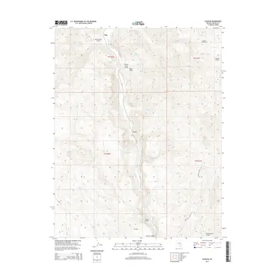
2014 Map of Elgin NE
USGS Topo · Published 2014About this map
Meadow Valley Wash defines the north-south drainage corridor of this Lincoln County landscape, carving a path between the high elevations of the Clover Mountains to the east and the rugged canyonlands to the west. The settlements of Stine and Boyd are positioned along this waterway, mirroring the path of NV-317 as it snakes through the valley floor. This environment is marked by numerous named springs that speak to the essential water sources in an arid region, including the curiously named Flying Machine Spring, Hummingbird Spring, and Cottonwood Springs.
Find a feature on this map
26 named features on this map. Tap any name to fly to it.
Don’t see what you’re looking for? This feature index may not catch every label — zoom into the map to look around manually.
Map Details
Editions of this 2014 Elgin NE Map
This is the sole edition of this map. No revisions or reprints were ever made.
Other maps of this area

1885 · Pioche
USGS Topo · 1:250,000

1886 · Pioche
USGS Topo · 1:250,000

1954 · Caliente
USGS Topo · 1:250,000

1959 · Caliente
USGS Topo · 1:250,000

1969 · Elgin
USGS Topo · 1:24,000

1969 · Elgin NE
USGS Topo · 1:24,000

1969 · Slidy Mountain
USGS Topo · 1:24,000

1969 · Elgin SW
USGS Topo · 1:24,000
1970 · Caliente
USGS Topo · 1:24,000
1970 · Chokecherry Mtn.
USGS Topo · 1:24,000