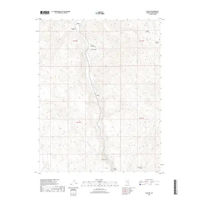
2018 Map of Elgin NE
USGS Topo · Published 2018About this map
Meadow Valley Wash carves a deep central corridor through this section of Lincoln County, dictating the placement of the transportation route and the small settlements of Stine and Boyd. To the east, the Clover Mountains dominate the high ground, dissected by a network of drainage systems including Sawmill Canyon and Whiskey Spring Canyon. The southern end of the quadrangle opens into Ash Flat and the entrance to Rainbow Canyon, reflecting a landscape where geological features and canyon passages have long defined the movement of people and resources. Smaller tributaries like Willow Cr and named depressions such as Kaolin Canyon provide specific points of reference for those studying the physical history of this desert environment. This map highlights how modern infrastructure continues to follow the natural lines of the valley floors.
Find a feature on this map
17 named features on this map. Tap any name to fly to it.
Don’t see what you’re looking for? This feature index may not catch every label — zoom into the map to look around manually.
Map Details
Editions of this 2018 Elgin NE Map
This is the sole edition of this map. No revisions or reprints were ever made.
Other maps of this area

1885 · Pioche
USGS Topo · 1:250,000

1886 · Pioche
USGS Topo · 1:250,000

1954 · Caliente
USGS Topo · 1:250,000

1959 · Caliente
USGS Topo · 1:250,000

1969 · Elgin
USGS Topo · 1:24,000

1969 · Elgin NE
USGS Topo · 1:24,000

1969 · Slidy Mountain
USGS Topo · 1:24,000

1969 · Elgin SW
USGS Topo · 1:24,000
1970 · Caliente
USGS Topo · 1:24,000
1970 · Chokecherry Mtn.
USGS Topo · 1:24,000