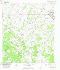
1982 Map of Elgin West
USGS Topo · Published 1982About this map
Elgin anchors the northeastern corner of this 1980s-era landscape, where the Southern Pacific rail line cuts a straight path toward the small community of Littig. The terrain is defined by a dense network of winding waterways, including Wilbarger Creek, Cottonwood Creek, and the Harris Branch, which dictate the irregular patterns of early Texas settlement roads. A prominent north-south boundary marks the Travis Co Bastrop Co line, dividing rural agricultural land and ranching properties. Genealogy researchers will find significant value in the numerous family and community burial grounds scattered across the area, such as Hog Eye Cem and Youngs Prairie Cem. The presence of Union Lee Ch and various local routes like Bittings School Road suggest a landscape deeply rooted in small-scale rural communities and local education centers before modern suburban expansion.
Find a feature on this map
43 named features on this map. Tap any name to fly to it.
Don’t see what you’re looking for? This feature index may not catch every label — zoom into the map to look around manually.
Map Details
Editions of this 1982 Elgin West Map
This is the sole edition of this map. No revisions or reprints were ever made.
Other maps of this area

1885 · Bastrop
USGS Topo · 1:125,000

1893 · Bastrop
USGS Topo · 1:125,000

1896 · Austin
USGS Topo · 1:125,000

1897 · Austin
USGS Topo · 1:125,000

1904 · Bastrop
USGS Topo · 1:125,000

1910 · Austin
USGS Topo · 1:125,000

1948 · Elgin
USGS Topo · 1:62,500

1948 · Bastrop
USGS Topo · 1:62,500

1950 · Bastrop
USGS Topo · 1:62,500

1950 · Elgin
USGS Topo · 1:62,500